![](/images/other/stat-length.png)
![Tocht Te voet Gars am Inn - Im Inndurchbruch - Photo](https://media.geolcdn.com/t/1900/400/9f2ebae6-8817-4dbe-86cf-7a894ba2c89f.jpeg&format=pjpeg&maxdim=2)
Im Inndurchbruch
SityTrail - itinéraires balisés pédestres
Tous les sentiers balisés d’Europe GUIDE+
![Lengte](/images/other/stat-length.png)
Lengte
4,1 km
![Max. hoogte](https://static1.geolcdn.com/siteimages/upload/files/1508320355ic_sort_altitude_max_24dp.png)
Max. hoogte
487 m
![Positief hoogteverschil](https://static1.geolcdn.com/siteimages/upload/files/1508320355ic_sort_den_pos_24dp.png)
Positief hoogteverschil
127 m
![Km-Effort](/images/other/stat-length.png)
Km-Effort
5,8 km
![Min. hoogte](https://static1.geolcdn.com/siteimages/upload/files/1508320355ic_sort_altitude_min_24dp.png)
Min. hoogte
415 m
![Negatief hoogteverschil](https://static1.geolcdn.com/siteimages/upload/files/1508320355ic_sort_den_neg_24dp.png)
Negatief hoogteverschil
114 m
![Boucle](https://static1.geolcdn.com/siteimages/upload/files/16400158638029165_repeat_loop_refresh_sync_direction_icon.png)
Boucle
Neen
Markering
Datum van aanmaak :
2022-02-11 19:16:57.387
Laatste wijziging :
2022-02-11 19:16:57.387
![Te voet](https://static1.geolcdn.com/sitytour/trail-icons/100.png)
1h18
Moeilijkheid : Gemakkelijk
![Scan deze QR-code om de tocht te openen in de SityTrail-applicatie](https://capi.geolives.com/qq0zvz2zws4bq2lad0pu/sitytour/trails/3100461/qr.png?size=200)
Gratisgps-wandelapplicatie
Over ons
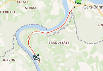
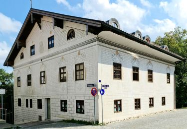
Tocht Te voet van 4,1 km beschikbaar op Beieren, Landkreis Mühldorf am Inn, Gars am Inn. Deze tocht wordt voorgesteld door SityTrail - itinéraires balisés pédestres.
Beschrijving
Symbol: Weiße Schilder mit rotem Wanderer, Richtungspfeil und der Aufschrift "Im Inndurchbruch"
Plaatsbepaling
Land:
Germany
Regio :
Beieren
Departement/Provincie :
Landkreis Mühldorf am Inn
Gemeente :
Gars am Inn
Locatie:
Unknown
Vertrek:(Dec)
Vertrek:(UTM)
298190 ; 5336178 (33U) N.
Opmerkingen
Wandeltochten in de omgeving
![Tocht Te voet Mühldorf a. Inn - Natur INN Bewegung - Photo](https://media.geolcdn.com/t/375/260/29bce5b0-e457-441c-998e-5a89ddc6344f.jpeg&format=jpg&maxdim=2)
![Te voet Te voet](https://static1.geolcdn.com/sitytour/trail-icons/100.png)
Natur INN Bewegung
Te voet
Gemakkelijk
Mühldorf a. Inn,
Beieren,
Landkreis Mühldorf am Inn,
Germany
![](/images/other/stat-length.png)
3,7 km | 4,3 km-effort
58min
![](https://static1.geolcdn.com/siteimages/upload/files/16400158638029165_repeat_loop_refresh_sync_direction_icon.png)
Neen
![Tocht Te voet Rott am Inn - Innauenweg - Photo](https://media.geolcdn.com/t/375/260/f1255ee4-e390-4d9a-acd6-1324e0744a2c.jpeg&format=jpg&maxdim=2)
![Te voet Te voet](https://static1.geolcdn.com/sitytour/trail-icons/100.png)
Innauenweg
Te voet
Gemakkelijk
Rott am Inn,
Beieren,
Landkreis Rosenheim,
Germany
![](/images/other/stat-length.png)
7,2 km | 8,1 km-effort
1h 50min
![](https://static1.geolcdn.com/siteimages/upload/files/16400158638029165_repeat_loop_refresh_sync_direction_icon.png)
Ja
![Tocht Te voet Isen - Durchs Isental - Photo](https://media.geolcdn.com/t/375/260/272ddd80-d5a8-4578-8ef6-002dca7fa8bf.jpeg&format=jpg&maxdim=2)
![Te voet Te voet](https://static1.geolcdn.com/sitytour/trail-icons/100.png)
Durchs Isental
Te voet
Gemakkelijk
Isen,
Beieren,
Landkreis Erding,
Germany
![](/images/other/stat-length.png)
14,8 km | 18,2 km-effort
4h 7min
![](https://static1.geolcdn.com/siteimages/upload/files/16400158638029165_repeat_loop_refresh_sync_direction_icon.png)
Ja
![Tocht Te voet Amerang - Großer Moosrundweg - Photo](https://media.geolcdn.com/t/375/260/ext.jpg?maxdim=2&url=https%3A%2F%2Fstatic1.geolcdn.com%2Fsiteimages%2Fupload%2Ffiles%2F1545311037marcheuse_200dpi.jpg)
![Te voet Te voet](https://static1.geolcdn.com/sitytour/trail-icons/100.png)
Großer Moosrundweg
Te voet
Gemakkelijk
Amerang,
Beieren,
Landkreis Rosenheim,
Germany
![](/images/other/stat-length.png)
5,3 km | 6,1 km-effort
1h 23min
![](https://static1.geolcdn.com/siteimages/upload/files/16400158638029165_repeat_loop_refresh_sync_direction_icon.png)
Ja
![Tocht Te voet Amerang - Kleiner Moosrundweg - Photo](https://media.geolcdn.com/t/375/260/ext.jpg?maxdim=2&url=https%3A%2F%2Fstatic1.geolcdn.com%2Fsiteimages%2Fupload%2Ffiles%2F1545311037marcheuse_200dpi.jpg)
![Te voet Te voet](https://static1.geolcdn.com/sitytour/trail-icons/100.png)
Kleiner Moosrundweg
Te voet
Gemakkelijk
Amerang,
Beieren,
Landkreis Rosenheim,
Germany
![](/images/other/stat-length.png)
3,6 km | 4,1 km-effort
56min
![](https://static1.geolcdn.com/siteimages/upload/files/16400158638029165_repeat_loop_refresh_sync_direction_icon.png)
Ja